Digiroad data has a WMS viewing interface and a WFS download interface, which enable efficient data transfer from Digiroad administrators to data users, municipal employees, public service providers and companies.
Information is updated to the WMS and WFS interfaces every weekend from Digiroad's database. TN-ITS change information is published daily.
Digiroad's WMS viewing interface allows you to view Digiroad's different data types and use them for visualization in applications or maps. The interface currently contains all Digiroad's data types, as well as the road link's feature information on the geometry of the design and construction phase.
We are happy to receive feedback on both the visualization methods of the WMS interface and the material itself.
WMS interfaces can be viewed, for example, in Paikkatietoikkuna, in the Finnish Transport Infrastructure map service called Suomen Väylät and in the Digiroad map window. The WMS interface (Web Map Service) is an interface that returns spatial data as a map image. The data can be viewed, but its appearance cannot be changed, nor can spatial data queries be made on it. However, the WMS services of Digiroad data include the possibility to make info queries to the data with the info tool of the GIS program.
Digiroad's WFS direct order interface allows you to download data from the area you want to use locally, for example with geospatial software. Currently, the recommended regional division for charging is the municipal level. The size of the entire Digiroad data in Finland is very large, so we recommend downloading small areas at a time to optimize the performance of the interface. The interface is also not designed to be used directly in applications and we recommend downloading data locally.
If you need access to data from a larger area, the Finnish Transport Infrastructure Agency's material service allows you to download the latest publication of the entire dataset as usual. The data can be downloaded as a Geopackage covering the whole of Finland or as a shape file divided into regions.
The WFS interface is recommended to be used by the division of municipalities into municipalities, and material downloaded from the WFS interface (Web Feature Service) can be utilized like any other spatial data layer. The data can be queried, for example, with QGIS software with SQL search:
SELECT * FROM DESIRED DATA TYPE WHERE DESIRED DATA TYPE. MUNICIPALITY CODE=eg. 179 or SELECT * FROM HALUTTUTIETOLAJI WHERE HALUTTUTIETOLAJI.KUNTAKOODI=eg. 179
Replace the DESIRED data type with the data type name in the interface and 179 (Municipality number) of the desired municipality.
Please note that line-like data types are very heavy, and in large municipalities the connection may be slow.
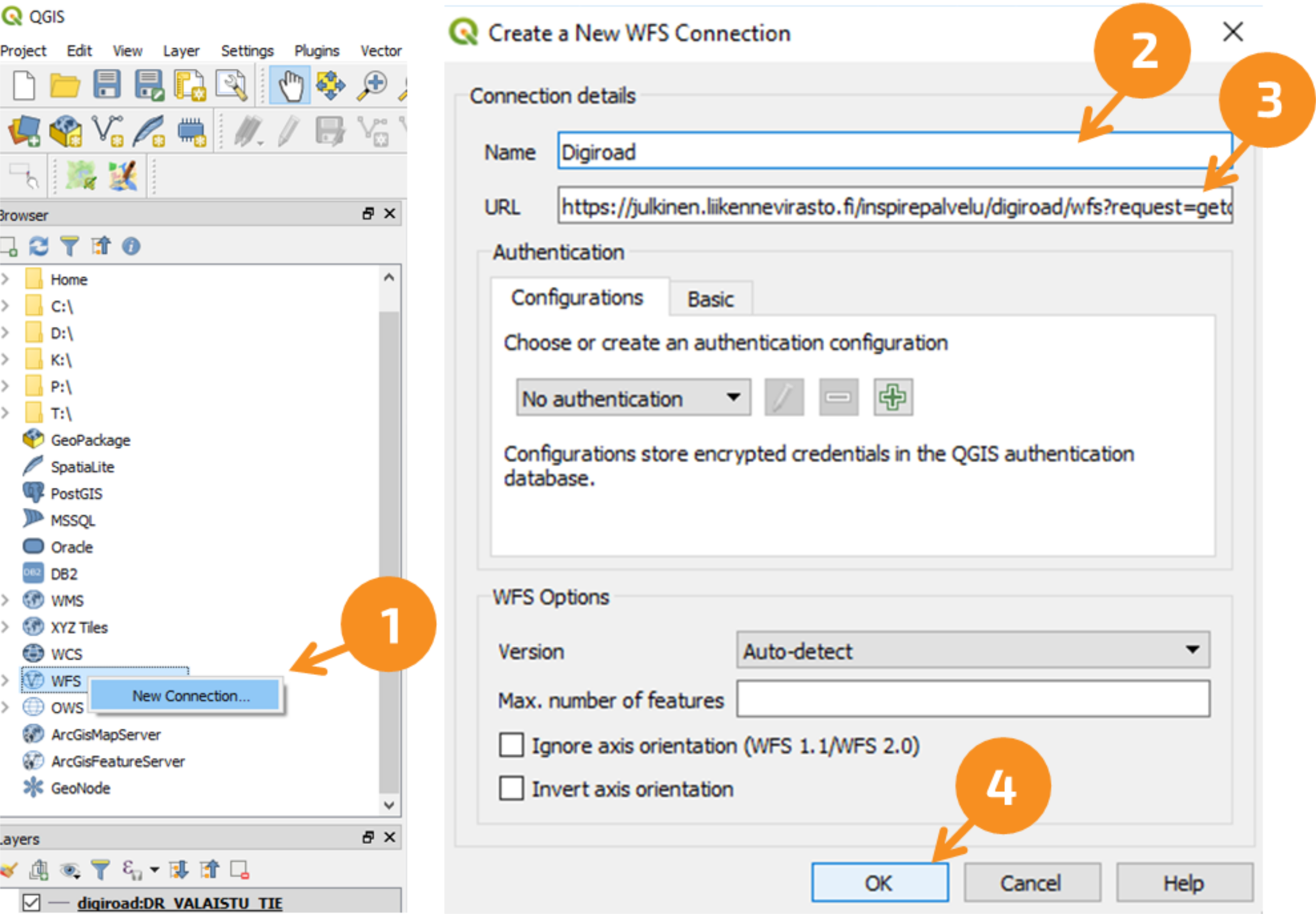
3. Copy the WFS-URL into the field. You can get the necessary address by copying the link above.
4. Press OK. The interface does not need identification.
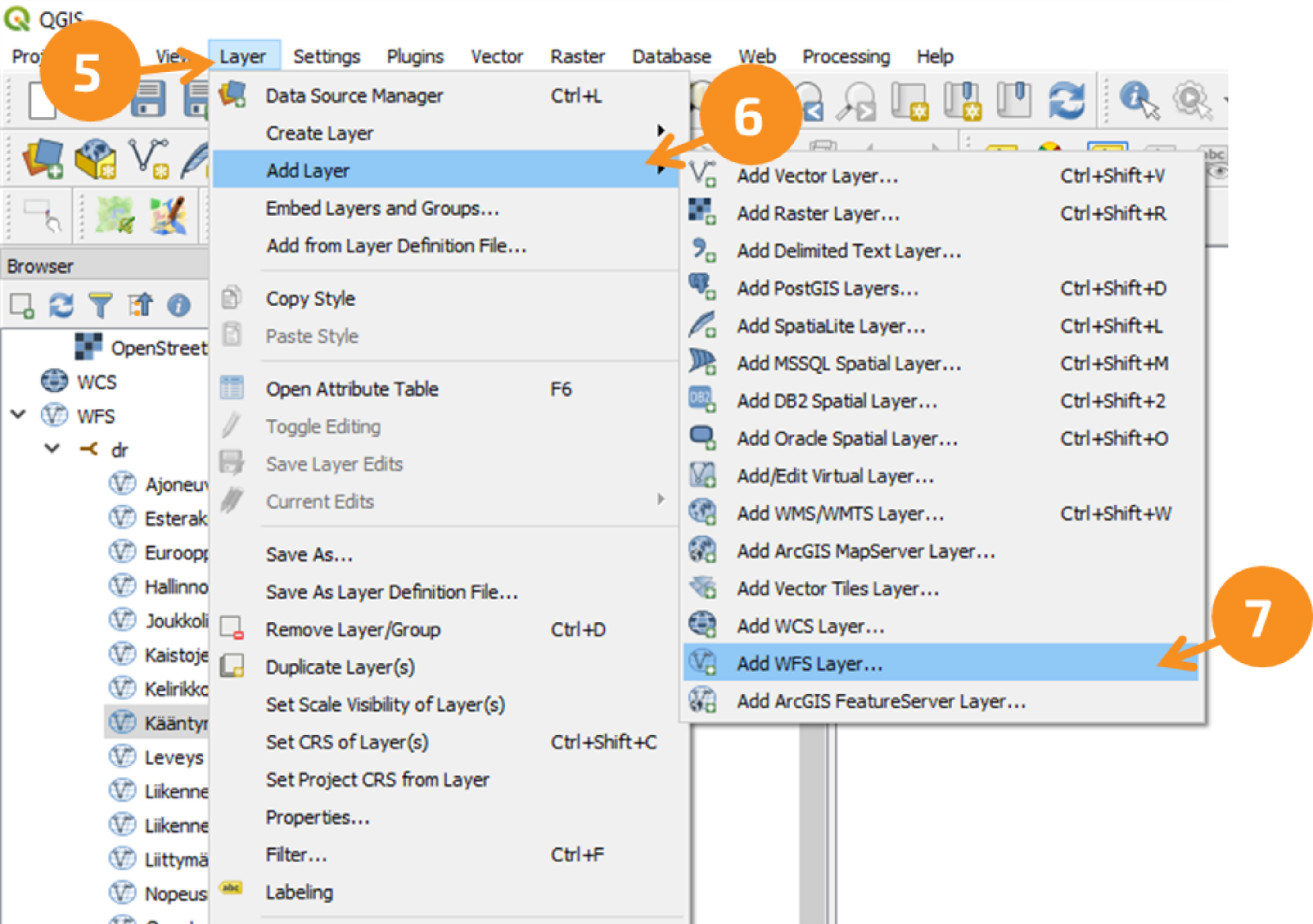
5. Add a new WFS layer by navigating to layer --> 6. Add layer --> 7. Add WFS-layer
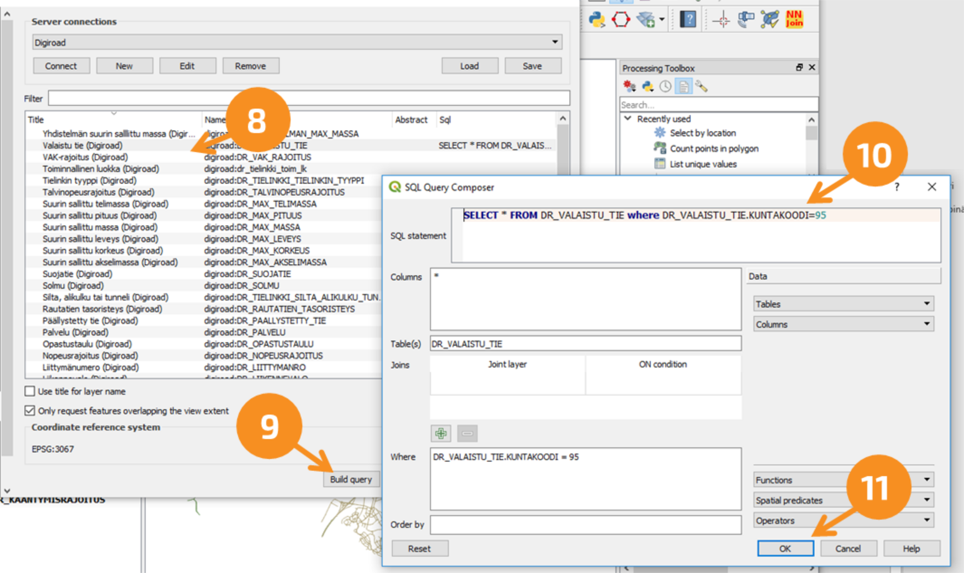
8. In the drop-down list, find the connection you named, and press Connect. Select one desired data type from the list that appears.
9. Limit the data to an individual municipality by clicking "Build query"
10. Copy the municipality boundary query in SQL language into the field, for example: SELECT * FROM DR_VALAISTU_TIE WHERE DR_VALAISTU_TIE. MUNICIPALITY CODE=95 . This query returns the Illuminated Road data type from the City of Helsinki area. N.B! In step 8, the data type you select must be in place of the data type in the SQL query for the query to pass. To change the data type, press the cancel button to cancel the query and select the data type you want.
TN-ITS CHANGE INTERFACE
TN-ITS interface based on to the CEN/TS 17268:2018 standard. Changes in the Digiroad data are published once a day at the TN-ITS interface. Change information is transmitted to end users as dataset XML files where the location of changes to Digiroad objects is reported with the OpenLR location reference (https://www.openlr.org/).
The advantage of the TN-ITS interface is the speed and ease of data processing, as instead of downloading the entire data, it is possible to access the changed objects directly.
Returns a list of existing datasets in chronological order from oldest to newest.
Datasets are individual change messages that list all changes in Digiroad's data types during the time period defined by the dataset (a more detailed list of the data types provided by the interface can be found under the main heading "TN-ITS: GET /download/readDataSet - Individual dataset dataset" below).
Authentication
The use of the interface does not require authentication.
Parameters
lastValidDataSetID (optional): The url of the most recently retrieved dataset encoded id. If configured, search lists all datasets created after the specified dataset. Otherwise, returns a listing of all existing datasets.
Return values
HTTP-200 (OK): XML format from oldest to newest time-ordered listing of available datasets. A single dataset is defined by the "RestDatasetRef" element, which is assigned by the "xlink:href" attribute to the location of the url dataset.
<RestDatasetRefList xmlns="http://www.ptvag.com/tnits/dataexchange/rest" xmlns:xsi="http://www.w3.org/2001/XMLSchema-instance" xmlns:xlink="http://www.w3.org/1999/xlink" xsi:schemaLocation="http://www.ptvag.com/tnits/dataexchange/rest https://avoinapi.vaylapilvi.fi/tnits/public/schemas/api/TN-ITS.xsd">
     <RestDatasetRef xlink:href="https://avoinapi.vaylapilvi.fi/tnits/public/download/readDataSet?dataSetID=%2BQBW3IlFSIWYYPDwF4Vc%2FQAAAYBOyKC7AAABgFPuEls%3D"/> <!-- Link to individual dataset (created 23.4.2022) -->
     <RestDatasetRef xlink:href="https://avoinapi.vaylapilvi.fi/tnits/public/download/readDataSet?dataSetID=%2BQBW3IlFSIWYYPDwF4Vc%2FQAAAYBT7hJbAAABgFkUbEQ%3D"/> <!-- Link to individual dataset (created 24.4.2022) -->
     <RestDatasetRef xlink:href="https://avoinapi.vaylapilvi.fi/tnits/public/download/readDataSet?dataSetID=%2BQBW3IlFSIWYYPDwF4Vc%2FQAAAYBZFGxEAAABgF46yZ4%3D"/> <!-- Link to individual dataset (created 25.4.2022) -->
 </RestDatasetRefList>
HTTP error responses:
HTTP 400 (BadRequest) if
• An internal error occurs while processing the request. Other possible mistakes
Returns the contents of the questioned dataset. Dataset includes additions, edits and deletions of data types that have occurred in Digiroad during a certain time period. The content of the change message has been implemented in accordance with TN-ITS CEN TS 17268.
Datasets are generated automatically once a day.
N.B! The interface uses redirects, which is why redirects must be enabled in the query. (See chapter Return values; HTTP-302)
The implementation includes change data for the following data types:
Speed limits
Maximum Allowed data types:
Maximum authorized length of the vehicle or combination of vehicles
Maximum permissible width of the vehicle
Maximum authorized vehicle height
Maximum permissible mass on the axle of the vehicle
Maximum authorized mass of the vehicle
Maximum authorized mass of the vehicle combination
Forced stop
Barrier constructions
Crosswalk
Vehicle-specific limit
Warning signs
The location of changes to Digiroad objects is reported with the OpenLR location reference. The direction of influence of the changed Digiroad target is explained as follows:
An OpenLR location reference in the same direction is generated from the change of a linear Digiroad object affecting one direction.
Two separate roadFeatures elements are formed from the change of the linear Digiroad object affecting both directions, both of which have a one-way OpenLR location reference. Both roadFeatures elements refer to the same Digiroad object.
Orientation information is generated from the direction of effect of point-like mandatory stopping and warning signs in the OpenLR location reference.
In addition to the OpenLR location reference, the dataset contains the geometry location reference as a gml string, but it does not take into account the target's direction of influence in any way.
The OpenLR location reference can be extracted on the demo.tomtom.com website.
Authentication:
The use of the interface does not require authentication.
Parameters
dataSetID: The URL of the dataset you want to query is the encoded id whose content you want to retrieve. The encoded ids of the URL of the available change messages can be retrieved using the dataset listing call (in the main header above: TN-ITS: GET /download/queryDataSets - Current data), which returns the full URLs for reading the datasets as an xml listing.
Return values
HTTP-302 (Found): Redirects the queryer to the file location using the location header. A dataset is an unordered listing in XML format of changes that have occurred during the time period specified in the dataset.
<RoadFeatureDataset xmlns="http://spec.tn-its.eu/schemas/" xmlns:xsi="http://www.w3.org/2001/XMLSchema-instance" xmlns:gml="http://www.opengis.net/gml/3.2" xmlns:xlink="http://www.w3.org/1999/xlink" xsi:schemaLocation="http://spec.tn-its.eu/schemas/ http://spec.tn-its.eu/schemas/TNITS.xsd">
     <metadata>
         <Metadata>
             <!-- Dataset id -->
             <!-- Consists of the search times for changes (start and end) and the UUID of the provider of the dataset -->
             <datasetId>+QBW3IlFSIWYYPDwF4Vc/QAAAYBOyKC7AAABgFPuEls=</datasetId>
             <!-- Dataset creationtime UTC-format -->
             <datasetCreationTime>2022-04-23T00:59:12.859Z</datasetCreationTime>
         </Metadata>
     </metadata>
     <!-- Dataset type "update" contains update information (only this is in use at the monent) -->
     <type>Update</type>
     <!-- Contains information about a single change. There can be either an empty <roadFeatures /> or there can be more of these ( 0..* ) -->
     <!-- You can find more details about the content of the change notice for individual data types on this subpage -->
     <roadFeatures />
 </RoadFeatureDataset>
Example: (Call to prod environment): Retrieves the contents of the dataset (id: "+QBW3IlFSIWYYPDwF4Vc/QAAAYBOyKC7AAABgFPuEls=" url encoded: "%2BQBW3IlFSIWYYPDwF4Vc%2FQAAAYBOyKC7AAABgFPuEls%3D").

.png/e8bcdaf1-e50a-4f73-f7df-f618e4829f52?t=1685605569131)